5. Completing Updates and Synchronizing the Changes to GMT Geodatabase
The final step is to synchronize the changes you have made with the server, which will in turn add them to the GMT geodatabase.
Warning
This step is not possible using the training version of GMT. Please read the instructions below, but do not attempt this section during your training, as it will not work.
5.1. Synchronization Steps
Establish a connection
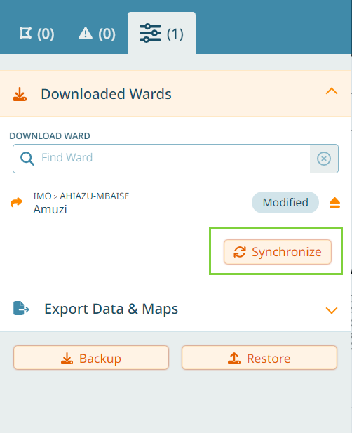
Navigate to the Data Management tab in the navigation panel and expand Downloaded Wards.
Check to see whether the ward has been modified.
Click Synchronize to upload the changes to the GMT geodatabase.
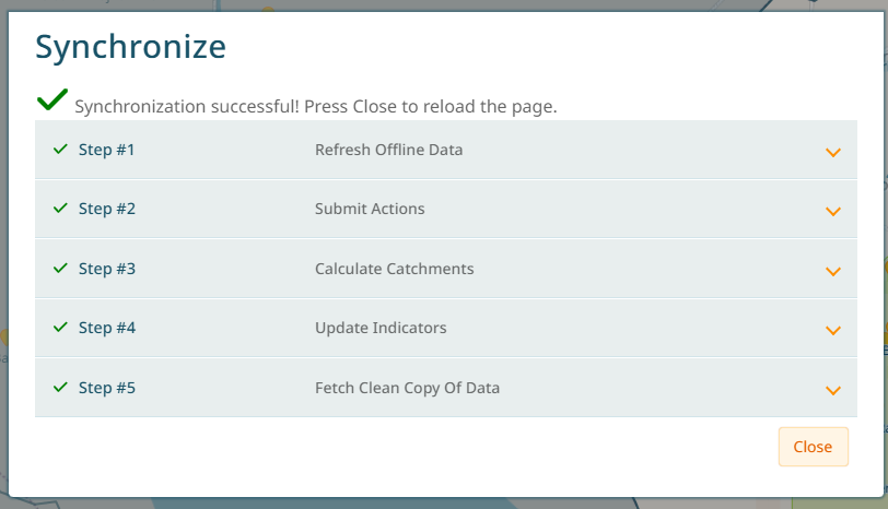
Click on Continue in the window that opens.
Wait until the synchronization has finished. This might take a while. Then click ‘Close’.
5.2. Exporting Data from GMT
Three types of data can be exported from GMT:
PDF ward maps.
Excel spreadsheets that contain attribute data in a tabular format.
A geodatabase containing geospatial data such as boundaries, catchment polygons, health facility points, and settlement points. These data can then be analyzed in other GIS software, if required.
Exports can be selected for one or several boundaries at once. There is an option to have one separate file for each boundary, or one file containing the information for all selected boundaries. Additionally, the PDF map can display an entire ward, or multiple maps can be created (each one detailing an individual health facility within the ward).
Navigate to the Manage tab and search for the region you wish to export. You can continue adding regions to the list until you are ready to export.
5.2.1. Export Options
First, click “add to export” for a ward, then click on ‘Export’, then the Export Map and Data dialog will appear with several options:
5.2.1.1. Map Settings
Export Map
Generate PDF maps of the selected areas
One detail page per health facility Create separate detailed maps for each health facility in addition to the ward overview map
5.2.1.2. Data Settings
Export Spreadsheet Generate an Excel file containing tabular data
Export REW Generate an Excel file in the REW format
Export GDB File Export a geodatabase file for use in other GIS software
Separate file for each boundary Create individual files for each selected ward/boundary instead of combining them
5.2.2. Excel Export Structure
Tabular data downloads are provided in four separate sheets:
5.2.2.1. GMT - Overview Sheet
Contains admin area names and total population data:
National - Country level data
State - State level data
LGA - Local Government Area data
Ward - Ward level data
POP GIS - GIS modeled population estimates
5.2.2.2. GMT - HFs Sheet
Contains health facility information and population summaries:
HF Name - Health facility name
HF State - State where facility is located
HF LGA - Local Government Area
HF Ward - Ward where facility is located
RI Strategy - Does the facility provide routine immunization service? (True/false)
Total STL - Number of settlements serviced by the facility
Total Catchment - Population within the facility catchment
Total FIXED - Population within the fixed facility catchment
Total OUTREACH - Population within the catchment of any outreach sites
5.2.2.3. GMT - STLs Sheet
Contains settlement information and population summaries:
Name - Settlement name
HF State - State
HF LGA - Local Government Area
HF Ward - Ward
STL in ward - Total number of settlements in the ward
Population Total - Pop GIS (modeled estimate), Pop estimated (field estimate), Pop difference (difference between the two estimates)
Uninhabited - Number of settlements marked as uninhabited for each of the following reasons:
Unknown
Abandoned
Destroyed
No settlement
Other
Special Attention - Number of settlements marked as a focus area for each of the following reasons:
cVDPV outbreak
Densely populated
Internally displaced
Measles outbreak
Nomadic/Fulani
Non-compliant
Polio high-risk
Riverine
Scattered
Security compromised
Slum
Uptake issue
Zero-dose
5.2.2.4. GMT - Catchments Sheet
Contains health facility catchment relationships with individual settlements, information and population summaries:
HF Name - Fixed post name, outreach site name or “mobile”
RI Strategy - Does the facility provide routine immunization service? (True/false)
Outreach Site Name - If applicable
Settlement Name - Name of settlement in catchment
Catchment Population Total - Total population served
Catchment Population Inside HF Ward - Population within the same ward as the health facility
Catchment Population Outside HF Ward - Population from neighboring wards
% of Settlement Population Assigned to HF - Percentage of settlement population assigned to this health facility
Distance Settlement HF (m) - Distance from settlement to health facility in meters
Distance Settlement Outreach Site (m) - Distance from settlement to outreach site in meters
5.3. Using Exported Data
5.3.1. PDF Maps
The PDF maps are designed for field use and include:
Ward overview showing all health facilities and settlements
Catchment areas clearly marked
Settlement names and population estimates
Transportation routes and geographic features
Legend explaining symbols and colors
Individual health facility maps (if selected) showing detailed catchment information
5.3.2. Excel Spreadsheets
The Excel files can be used for:
Data analysis and reporting
Population planning calculations
Coverage assessment
Performance monitoring
Integration with other health information systems
5.3.3. Geodatabase Files
The GDB files contain:
Vector layers for boundaries, health facilities, settlements
Catchment polygons for each health facility
Population raster data
Attribute tables with all collected information
5.4. Best Practices for Exporting
5.4.1. Planning Your Export
Review data quality before exporting - resolve outstanding issues first
Coordinate with team - ensure all team members have completed their updates
Check completeness - verify all required health facilities and settlements are included